Talking to spaceborne RADAR: Sentinel1 data processing
... and seeing a corner reflector as cooperative target
- Track: Free Software Radio devroom
- Room: D.radio
- Day: Sunday
- Start: 12:00
- End: 12:50
- Video with Q&A: D.radio
- Video only: D.radio
- Chat: Join the conversation!
J.-M Friedt & P. Abbé
Signal processing of Sentinel1 spaceborne RADAR datasets freely available from the European Space Agency web site, followed by the deployment of a corner reflector which will be visible in the latest datasets.
Software Defined Radio users and developers are well aware of the {I, Q} stream and their handling for powerful software processing at baseband. While most developments focus on hardware, acquisition and digital communication signal decoding, a huge dataset of {I, Q} samples is available from the spaceborne Sentinel1 satellites. Indeed, the European Space Agency is providing free access (the anonymous registration with the service will be discussed in the presentation) to the datasets collected by the two Sentinel-1{A, B} satellites. Spaceborne RADAR provide all-weather (RADAR is not affected by cloud), day-night (RADAR is active and does not depend on external illumination sources) monitoring conditions covering the whole surface of the Earth from the low Earth polar orbiting satellites. Most significant over optical measurements, microwave RADAR measurements allow for phase recovery and hence interferometric measurement which is not possible with optical measurements. Furthermore, radiofrequence wave complex interactions with the reflective surfaces (scattering, absorption, polarization rotation) provides a rich context for analysis complementary to optical observations.
Thanks to the Single Look Complex, Interferometric Wide datasets collected over land, discovering Interferometric Synthetic Aperture RADAR processing is no longer a matter of being associated with a dedicated laboratory and applying to selective research projects (e.g. Canadian RADAR-Sat datasets or German TanDEM-X) but only of fetching the huge datasets (4-GB/image) and learning the processing sequence.
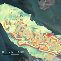
In this talk which will appear as a sequel to the development of Ground Based SDR RADAR discussed during GRCon2020 [1], we will introduce a processing flowchart first relying on the SNAP graphical user interface provided by ESA before switching to an automated command line approach relying on Makefile since each processing step depends on the proper completion of the previous one. We will address some basic conditions whose results are expected, namely German open-pit coal mines and earthquake-induced land motion. Indeed the 5 mx20 m pixel and 5.6 cm wavelength is best suited for large scale, sub-cm natural or human-induced geomorphological transformations, while the short term coherence is best achieved by analyzing the successive data collected from one observation to another with a 12-day repetition rate.
After demonstrating a functional flowchart resulting in GeoTIFF phase and coherence maps consistent with optical satellite and aerial imagery, we conclude the presentation by adding a cooperative target corner reflector acting as localized point-like measurement source, assuming the reflector is large enough to be the dominant reflection source over the pixel area.
[1] Software defined radio based Synthetic Aperture noise and OFDM (Wi-Fi) RADAR mapping, GRCon 2020, at https://pubs.gnuradio.org/index.php/grcon/article/view/71
Speakers
| Jean-Michel Friedt |