Creating georeferenced digital elevation models from unmanned aerial vehicle images
- Track: Geospatial devroom
- Room: H.2214
- Day: Sunday
- Start: 14:00
- End: 14:25
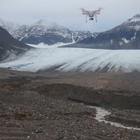
With the proliferation of unmanned aerial vehicles (UAV) on the one hand, and the availability of Structure from Motion (SfM) algorithm [1] in the opensource Micmac [2, 3, 4] software suite (French National Geographic Institute, IGN) for generating Digital Elevation Models (DEM) and orthophotos on the other hand, we describe the processing chain to acquire and geoereference DEMs in QGIS. The fast acquisition and very high (sub-meter) resolution are well suited for repeated measurements and assess terrain morphological changes. The processing sequence is
fly and acquire georeferenced images. If only a GPS receiver and camera are aboard the UAV, matching time tag with GPS date and time will allow for georeferencing the pictures (exiftool)
identify matching points between adjacent images: the GPS position is used to reduce the number of comparisons and limit the lengthy analysis to nearest neighbors
identify lens properties, bringing the largest cause of uncertainty in the model generation, from various pictures of the same ground feature exhibiting as much height variation as possible,
generate coarse point cloud to assess camera position and matching algorithm consistency
generate dense point cloud, orthophoto and DEM
include the resulting georeferenced pointcloud in QGis, converting the (arbitrary TIF) pixel value to quantitative height (meters).
We demonstrate sub-meter resolution DEM generation in vegetation-less environments (urban, glacier moraine) while coarse-acquisition (C/A) single-frequency GPS only allows for 5-m accuracy, hence requiring an additional ground control point matching step for repeated DEM comparison.
This presentation is a shortened sequel to the FOSS4G presentation given in 2016 (in French at the moment) focusing on UAV azimutal images.
[1] Nolan, M., Larsen, C. F., and Sturm, M.: Mapping snow-depth from manned-aircraft on landscape scales at centimeter resolution using Structure-from-Motion photogrammetry, The Cryosphere Discuss., 9, 333-381, doi:10.5194/tcd-9-333-2015, 2015
[2] J. Lisein, M. Pierrot-Deseilligny, S. Bonnet, P. Lejeune. A PhotogrammetricWorkflow for the Creation of a Forest Canopy Height Model from Small Unmanned Aerial System Imagery. Forests, Volume 4, Issue 4, pp.922-944, dx.doi.org/10.3390/f4040922, December 2013
[3] Daakir M., Pierrot Deseilligny M. , Pichard F., Bosser P (2015). & Thom C., UAV photogrammetry and GPS positioning onboard for earthworks, ISPRS Journal of Photogrammetry and Remote Sensing
[4] Github archive and its excellent documentation
Speakers
| Jean-Michel Friedt |